|
 |
| |
|

Syrian
National Anthem
Defenders of the realm,
Peace on you;
Our proud spirits will
Not be subdued.
The adobe of Arabism,
A hallowed sanctuary;
The seat of the stars,
An inviolable preserve.
Syria's plains areTowers in the heights,Resembling
the sky
Above the clouds.
A land resplendent
With brilliant suns,
Becoming another sky,
Or almost a sky.
|
|
 |
Patriot's
songs:
National
Anthem
Bilad
Al3orb
Mawtini
Sa2elini
Souria
ya habibaty
Sourya
laki alsalam
Ya
salam |
Facts:
Syria gained full independence on April
17, 1946 ceding from French Colonialism Rule. Prior
to French Occupation, Syria was part of the Ottoman
Empire under Turkish Rule. Today Modern Day Syria
is a vital Arab Republic that stands for Arab and
International Legitimacy Law.
Syria is a member of the United Nations, the Arab
League, the Organization of the Islamic Conference
(OIC) and many other International Organizations. |
Climate:
The climate of Syria varies from Mediterranean at
the coast to dry in the interior region.Rainy winters
(December to February) along coast; cold weather
with snow or sleet periodically in Damascus The
geographical location of Syria and its climate variation
made it possible for about 3500 kinds of plants
to grow. |
Natural resources:
petroleum, phosphates, chrome and manganese ores,
asphalt, iron ore, rock salt, marble, gypsum, hydropower
|
|
|
|
|
|
|
|
|
 |
| |
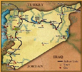 |
Location:
Modern Syria is situated in Asia along the eastern
edge of the Mediterranean Sea. Syria is an Arab
Middle Eastern County that encompasses a total area
of 185,180 sq. km (71,548 sq. mi.). Syria has a
coastline of 180 km (112) miles to the Mediterranean
Sea. Syria shares borders with, Lebanon to the West,
Turkey to the North, Iraq to the East, and Jordan
to the South. Syria, also shares borders with Palestine
to the south west. |
| |
|
|
| |
Facts:
Official name: The Syrian Arabic Republic
local short form:
Suriyah
Capital:Damascus
Government type: republic under military regime
since March 1963
Location: Middle East, bordering the Mediterranean
Sea, between Lebanon and Turkey
Map Reference: Middle East
Area: 185,180 sq km includes 1,295 sq km of Israeli-occupied
territory.
Population: 18,016,874 in addition, about 40,000
people live in the Israeli-occupied Golan Heights
Population growth: 2.4% (2004 est.)
Birth growth: 28.93 births/1,000 population (2004
est.)
Death growth: 4.96 deaths/1,000 population (2004
est.)
Age structure: 0-14 years: 38% (male 3,524,406;
female 3,319,323)
15-64 years: 58.7% (male 5,421,133; female 5,163,669)
65 years and over: 3.3% (male 281,795; female 306,548)
(2004 est.)
Literacy: definition: age 15 and over can read
and write
total population: 76.9%
male: 89.7%
female: 64% (2003 est.)
languages: Arabic (official); Kurdish, Armenian,
Aramaic, Circassian widely understood; French, English
somewhat understood
Religions: Muslim 84%, Christian16%,1% others
Ethnic group: Arab 90.3%, Kurds, Armenians, and
other 9.7%
GOVERNORATES
Syria is divided into 13 governorates and the municipality
of Damascus. The capital and largest city of the country
is Damascus.
Aleppo ,Homs, Damascus City, Idlib, Damascus, Latakia,Deir
Ez Zor, Quneitra
Dara, Raqqa, Hama, Suwieda, Hassake, Tartus.
Brief
Political History of Syria
Damascus Came under Muslim rule in A.D.636. and it became
the capital of Omayyad Empire from A.D. 661 to A.D.
750, when the Abbasid caliphate was established at Baghdad,
Iraq. Later, around 1260 it became a provincial capital
of Mameluke Empire. It was largely destroyed in 1400
by Tamerlane, the Mongol conqueror, who removed many
of its craftsmen to Samarkand. Rebuilt, it continued
to serve as a capital until 1516. In 1517, it fell under
Ottoman rule. They remained for the next 400 years,
except for a brief occupation by Ibrahim Pasha of Egypt
from 1832 to 1840. In 1920, an independent Arab kingdom
of Syria was established under king Faysal of the Hashemite
family. His rule ended after few months, following the
clash between Syrian forces and regular French forces
at the battle of Maysalun. French troops occupied Syria
later that year after the league of Nations put Syrian
under the French mandate. With the fall of France in
1940, Syria came under the control of the Vichy Government
until the British and Free French occupied the country
in July 1941. Continuing pressure from Syrian nationalist
groups forced the French to evacuate their troops in
April 1946, leaving the country in the hands of a republican
government that had been formed during the mandate.
Independence to 1970
Although rapid economic development followed the declaration
of independence of April 17, 1946, Syrian politics from
independence through the late 1960s was marked by upheaval.
A series of military coups, begun in 1949, undermined
civilian rule and led to army colonel Adib Shishakli's
seizure of power in 1951.President Shishakli overthrown
power in a 1954 coup and deported to Brazil. continued
political maneuvering supported by competing factions
in the military eventually brought Arab nationalist
and socialist elements to power.
Syria's political instability during the years after
the 1954 coup, the parallelism of Syrian and Egyptian
policies, and the appeal of Egyptian President Gamal
Abdel Nasser's leadership in the wake of the 1956 Suez
crisis created support in Syria for union with Egypt.
On February 1, 1958, the two countries merged to create
the United Arab Republic, and all Syrian political parties
ceased overt activities.
The union was not a success, however. Following a military
coup on September 28, 1961, Syria seceded, re-establishing
itself as the Syrian Arab Republic. Instability characterized
the next 18 months. Later on March 8, 1963, Al Ba'ath
Party took over, which had been active in Syria and
other Arab countries since the late 1940s.
|
|
|